Proposal for an improved handling of ship-based data
Gathering data in the vastness of the world's oceans is tedious: year after year, research ships cross the sea, but only small sections of the ocean can be surveyed at any one time. This applies once again to observations of the atmosphere, which are rarely the focus of such expeditions. The measured data is thus very valuable, and being able to use it in a variety of ways and combine observations from different ship expeditions is particularly important.
The gold standard in science is therefore data management guided by the FAIR principles: data should be findable, accessible, interoperable and reusable. This is achieved, for example, by archiving data in publicly accessible repositories and describing it in a way that makes it as easy as possible for anyone to use.
But even evaluating data that meets the FAIR principles can be tedious if it comes from different expeditions. Julia Windmiller, a researcher at the Max Planck Institute for Meteorology (MPI-M), knows this from her own experience: "The data is originally available in different file formats, measured variables are labeled inconsistently and have to be processed in different ways," explains the atmospheric physicist. "In addition, the data belongs to different institutions and is provided in different temporal and/or spatial resolutions. This makes it difficult to use them in a holistic way."
A blueprint for ship-based observations
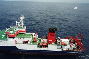
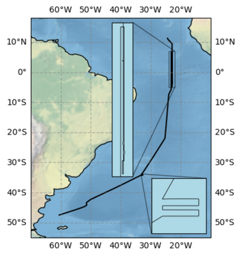
Windmiller and her colleagues have now proposed a standardized approach that should make everyone's work easier in the future. The team led by Laura Köhler (also MPI-M, now Alfred Wegener Institute) illustrates this approach using the example of a campaign carried out in 2023 with the German research vessel Maria S. Merian. The "Atlantic References and Convection" (ARC) expedition in the tropical Atlantic served to explore the Intertropical Convergence Zone (ITCZ), a band of clouds near the equator. The scientific crew recorded various atmospheric and oceanographic parameters – some of them continuously, others on individual occasions or during stops at stations.
Following the campaign, the scientists have shown how this data can be processed in a clear and standardized way: The extensive data set published on the PANGAEA data archive uses uniform time steps, labelling according to international standards, the International System of Units (SI) and provides the computer programs used for processing as well. These can be adapted for future campaigns, even if different instruments are used or different parameters are recorded. "We are thus providing a comprehensive overall package consisting of the data sets, a corresponding paper, the processing routines used in the form of a GitHub repository, and the Python package 'shipspy', which contains the computer programs that other research groups can easily continue to use," summarizes Laura Köhler. "We hope to provide a blueprint for ship-based measurements that will help to enhance and further expand the existing wealth of data."
New insights into the internal structure of the ITCZ
The researchers also illustrate the scientific insights that can be gained from the ARC data. During the four-week research trip from the African island state of Cape Verde to Chile, the ship crossed the ITCZ three times. The analysis shows: Based on the content of water vapor in the atmosphere as well as wind speed and direction, the scientists can precisely determine the position of the ITCZ as well as the inner structure of the cloud band. In particular, regions of conspicuously low wind speed are revealed – the so-called doldrums, for which Julia Windmiller recently presented a new theory. The recently published measurements, as well as further planned measurements, should help to confirm the theory and learn more about the inner structure of the ITCZ. The proposed concept for handling the valuable data should significantly simplify the compilation of such ship-based measurement data in the future.
Original publications
Köhler, L., Windmiller, J., Baranowski, D., Brennek, M., Ciuryło, M., Hayo, L., Kȩpski, D., Kinne, S., Latos, B., Lobo, B., Marke, T., Nischik, T., Paul, D., Stammes, P., Szkop, A., and Tuinder, O.: Calm ocean, stormy sea: atmospheric and oceanographic observations of the Atlantic during the Atlantic References and Convection (ARC) ship campaign, Earth System Science Data, 17, 633–659, https://doi.org/10.5194/essd-17-633-2025, 2025
Köhler, L., Baranowski, D. B., Brennek, M., Ciuryło, M., Hayo, L., Jansen, F., Kepski, D., Kinne, S., Latos, B., Lobo, B., Marke, T., Nischik, T., Paul, D., Pietruczuk, A., Stammes, P., Szkop, A., Tuinder, O., and Windmiller, J.: Standardized data sets of the atmospheric and oceanographic observations gathered during MARIA S. MERIAN cruise MSM114/2 (ARC), PANGAEA [data set], https://doi.org/10.1594/PANGAEA.966616, 2024
Köhler, L.: ARC: Processing of atmospheric and oceanographic measurements, Github [code], https://github.com/LauraKoehler/arc_processing, 2023.
Köhler, L.: shipspy, version 1.0.0, Github [code], https://github.com/shipspy-development/shipspy, 2024.
Contact
Dr. Laura Köhler
Alfred Wegener Institute Helmholtz Center for Polar and Marine Research
laura.koehler@awi.de
Dr. Julia Windmiller
Max Planck Institute for Meteorology
julia.windmiller@mpimet.mpg.de