
Why stratospheric aerosol disproportionately cools the Indian and western Pacific Ocean
In a new study Moritz Günther, Hauke Schmidt, Claudia Timmreck, and Matthew Toohey show how aerosol perturbations in the stratosphere lead to a…

Why is climate stochastic?
A time series of a climate variable often resembles a random sequence. This apparent randomness is generally attributed to the unpredictable and…

Climate change amplified by permafrost cloud feedback
Researchers at the Max Planck Institute for Meteorology shed light on what may happen if the frozen soils thaw in response to global heating.…
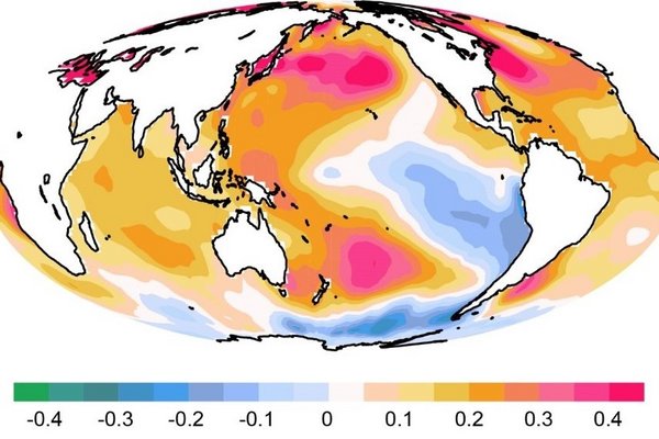
Changes to the Warming Pattern in the Tropical Pacific
The Earth is rapidly warming in response to human-induced greenhouse gas emissions. The warming is however not uniform, with some areas of the Earth…

Linear climate response to idealized tropical volcanic eruptions
In a new study, Dr. Claudia Timmreck, Dr. Dirk Olonscheck and Dr. Shih-Wei Fang from the Max Planck Institute for Meteorology, together with…
A new mechanism for synchronising Heinrich events with Dansgaard-Oeschger cycles
The northern hemisphere climate during the last glacial period (about 65,000-15,000 years before present) was dominated by two prominent signals of…
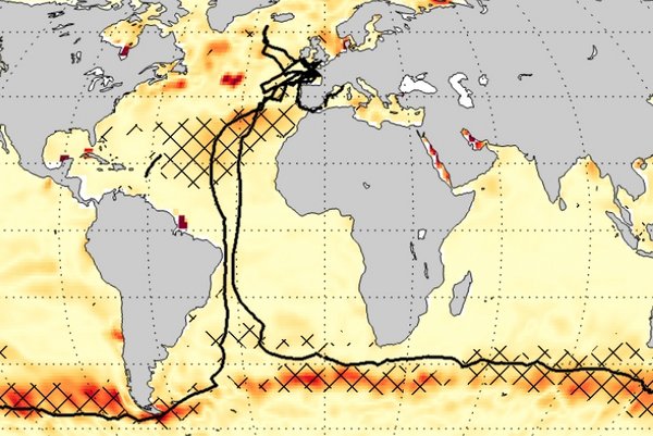
Ocean CO2 measurements: a single sailboat yacht makes a difference
Have you ever wondered how much a single measurement campaign matters when estimating the ocean's carbon sink? In a study published recently in…

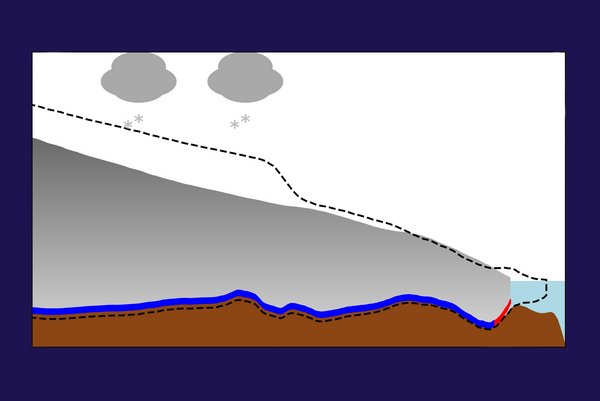
What happens after a snowball Earth melts?
When a snowball Earth deglaciates, the planet transitions rapidly into a hot "supergreenhouse" climate that persists for a hundred thousand years or…

Coupled climate models systematically underestimate the radiation response to surface warming
Do climate models realistically represent the coupling between Earth’s surface warming and the top-of-the atmosphere radiation? Dirk Olonscheck,…

Including icebergs in computer models helps to better understand past climate change
In their new study Olga Erokhina and Uwe Mikolajewicz showed that adding icebergs to climate models can help scientists better understand the…
Rain rather likes dry soils in a next-generation global climate model
In a recent study, Dr. Junhong Lee and Dr. Cathy Hohenegger show that a next-generation climate model exhibits a different relationship between water…

Towards resolving internal tides in the ocean
In a recent publication, Prof. Jin-Song von Storch together with other scientists showed that the ocean component of the ICON model is able to…