Central IT Services
IT services are provided at MPI-M by the Central IT Services (CIS) group.
The most important services of the Central IT Services are:
- Procurement, setup and management of IT hardware and software for both users (laptops, PCs) and infrastructure (servers, networks, etc.)
- Central user administration
- Provision of an efficient network (LAN, WLAN)
- Central IT help desk as a contact point for all IT-related issues
- Provision of services to support daily work (e.g. version management, project management, websites, etc.)
- Ensuring secure IT operations (failover, backup, IT security)
Detailed documentation on the IT Group’s offerings can be found in the Wiki of the institute.
An account (username and password) is required to use most IT services. Usually, an account will be created for you as soon as you have a contract with MPI-M. If you are a guest at MPI-M and need an account, your group leader at MPI can request an account for you. Further details are described in the institutes Wiki.
If you have any questions or problems using the IT systems at MPI-M, please contact the IT help desk.
Please note that questions regarding the DKRZ systems (e.g. Levante or data archive) will be answered by the DKRZ user support.
Contact
Rainer Weigle
Group leader
Tel.: +49 (0)40 41173-373
rainer.weigle@mpimet.mpg.de
Helpdesk
Tel.: +49 (0)40 41173-361
help-it@mpimet.mpg.de
More Content
New study sinks an old theory for low-wind equatorial regions
This is an excerpt of a press release by the American Geophysical Union.
During the Age of Sail, sailors riding the trade winds past the equator dreaded becoming stranded in the doldrums, a meteorologically distinct region in the deep tropics. For at least a century, scientists have thought that the doldrums’ lack of wind was caused by converging and rising air masses. Now, new research published in the journal Geophysical Research Letters suggests that the opposite may be true.

“The idea of what causes the doldrums came from a time where we didn't know a lot about how air actually moves in the tropics,” said Julia Windmiller, an atmospheric scientist at the Max Planck Institute for Meteorology and the study’s author. “We have forgotten about the doldrums to such a degree that nobody has taken the trouble of thinking through this original argument again.”
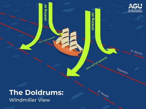
Instead, Windmiller proposes that low-to-no wind speeds throughout the doldrums are created by large areas of sinking air that diverge at the surface, creating clear and windless days. The research challenges the conventional explanation for the tropical, oceanic phenomenon that has stranded sailors, inspired poets and largely slipped out of the scientific literature.
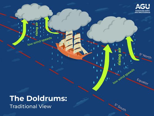
Traditionally, areas of low-to-no wind around the equator have been explained by converging and rising air masses. And while those air masses do create low-pressure, low-wind areas at the surface, that theory can only explain the doldrums’ extended regions of low winds when many areas of convergence are averaged together over days or weeks. In the short term, those converging air masses do not cover large enough areas to create windless regions that can last for days.
Deciphering the doldrums
The doldrums, also known as the Intertropical Convergence Zone, are usually characterized as a region of converging trade winds and rising air masses near the equator. The air masses, warmed by equatorial heat, float upwards like balloons, form clouds and whip up storms over the equator. They then sink back down at approximately 30 degrees North and South of the equator, completing what is known as Hadley Cell circulation. This pattern of converging and rising air near the equator has traditionally been accepted as the cause for the doldrums, as pockets of low-to-no winds are generally created under rising air masses.
Windmiller analyzed Intertropical Convergence Zone meteorological data for the Atlantic Ocean between 2001 and 2021 and buoy data ranging from 1998 to 2018 to define the edges of the Intertropical Convergence Zone and investigate low wind speed events in the region.
Low wind speed events are characterized by winds blowing at less than three meters per second, or five knots (the minimum speed required for sailing), for at least six hours. Windmiller examined the data on multi-day, hourly and minute-by-minute timescales, and considered how the low wind speed events evolved over time.
She found that low wind speed events coincided with clear weather conditions, lowered air temperatures and a lack of precipitation, conditions that point to sinking air masses diverging at the surface rather than rising air masses.
And while modern mariners are unlikely to be stranded in the doldrums, understanding their true cause could have present-day impacts. New, high-resolution climate models struggle to simulate regions of low wind speeds, so understanding the doldrums could change model predictions of precipitation and wind patterns.
“We can no longer explain these low wind speed events in the way we’ve done before,” said Windmiller. “I hope that this is something that people will see and read, and realize that the explanation is really upside down from what we’ve had.”
Read the full press release and find accompanying images on the AGU website.
Original publication
J. M. Windmiller: The Calm and Variable Inner Life of the Atlantic Intertropical Convergence Zone: The Relationship Between the Doldrums and Surface Convergence. Geophysical Research Letters.
https://doi.org/10.1029/2024GL109460
Contact
Dr. Julia Windmiller
Max Planck Institute for Meteorology
julia.windmiller@mpimet.mpg.de
New study sinks an old theory for low-wind equatorial regions
This is an excerpt of a press release by the American Geophysical Union.
During the Age of Sail, sailors riding the trade winds past the equator dreaded becoming stranded in the doldrums, a meteorologically distinct region in the deep tropics. For at least a century, scientists have thought that the doldrums’ lack of wind was caused by converging and rising air masses. Now, new research published in the journal Geophysical Research Letters suggests that the opposite may be true.

“The idea of what causes the doldrums came from a time where we didn't know a lot about how air actually moves in the tropics,” said Julia Windmiller, an atmospheric scientist at the Max Planck Institute for Meteorology and the study’s author. “We have forgotten about the doldrums to such a degree that nobody has taken the trouble of thinking through this original argument again.”

Instead, Windmiller proposes that low-to-no wind speeds throughout the doldrums are created by large areas of sinking air that diverge at the surface, creating clear and windless days. The research challenges the conventional explanation for the tropical, oceanic phenomenon that has stranded sailors, inspired poets and largely slipped out of the scientific literature.
Traditionally, areas of low-to-no wind around the equator have been explained by converging and rising air masses. And while those air masses do create low-pressure, low-wind areas at the surface, that theory can only explain the doldrums’ extended regions of low winds when many areas of convergence are averaged together over days or weeks. In the short term, those converging air masses do not cover large enough areas to create windless regions that can last for days.
Deciphering the doldrums
The doldrums, also known as the Intertropical Convergence Zone, are usually characterized as a region of converging trade winds and rising air masses near the equator. The air masses, warmed by equatorial heat, float upwards like balloons, form clouds and whip up storms over the equator. They then sink back down at approximately 30 degrees North and South of the equator, completing what is known as Hadley Cell circulation. This pattern of converging and rising air near the equator has traditionally been accepted as the cause for the doldrums, as pockets of low-to-no winds are generally created under rising air masses.
Windmiller analyzed Intertropical Convergence Zone meteorological data for the Atlantic Ocean between 2001 and 2021 and buoy data ranging from 1998 to 2018 to define the edges of the Intertropical Convergence Zone and investigate low wind speed events in the region.

Low wind speed events are characterized by winds blowing at less than three meters per second, or five knots (the minimum speed required for sailing), for at least six hours. Windmiller examined the data on multi-day, hourly and minute-by-minute timescales, and considered how the low wind speed events evolved over time.
She found that low wind speed events coincided with clear weather conditions, lowered air temperatures and a lack of precipitation, conditions that point to sinking air masses diverging at the surface rather than rising air masses.
And while modern mariners are unlikely to be stranded in the doldrums, understanding their true cause could have present-day impacts. New, high-resolution climate models struggle to simulate regions of low wind speeds, so understanding the doldrums could change model predictions of precipitation and wind patterns.
“We can no longer explain these low wind speed events in the way we’ve done before,” said Windmiller. “I hope that this is something that people will see and read, and realize that the explanation is really upside down from what we’ve had.”
Read the full press release and find accompanying images on the AGU website.
Original publication
J. M. Windmiller: The Calm and Variable Inner Life of the Atlantic Intertropical Convergence Zone: The Relationship Between the Doldrums and Surface Convergence. Geophysical Research Letters.
https://doi.org/10.1029/2024GL109460
Contact
Dr. Julia Windmiller
Max Planck Institute for Meteorology
julia.windmiller@mpimet.mpg.de
New study sinks an old theory for low-wind equatorial regions
This is an excerpt of a press release by the American Geophysical Union.
During the Age of Sail, sailors riding the trade winds past the equator dreaded becoming stranded in the doldrums, a meteorologically distinct region in the deep tropics. For at least a century, scientists have thought that the doldrums’ lack of wind was caused by converging and rising air masses. Now, new research published in the journal Geophysical Research Letters suggests that the opposite may be true.

“The idea of what causes the doldrums came from a time where we didn't know a lot about how air actually moves in the tropics,” said Julia Windmiller, an atmospheric scientist at the Max Planck Institute for Meteorology and the study’s author. “We have forgotten about the doldrums to such a degree that nobody has taken the trouble of thinking through this original argument again.”

Instead, Windmiller proposes that low-to-no wind speeds throughout the doldrums are created by large areas of sinking air that diverge at the surface, creating clear and windless days. The research challenges the conventional explanation for the tropical, oceanic phenomenon that has stranded sailors, inspired poets and largely slipped out of the scientific literature.
Traditionally, areas of low-to-no wind around the equator have been explained by converging and rising air masses. And while those air masses do create low-pressure, low-wind areas at the surface, that theory can only explain the doldrums’ extended regions of low winds when many areas of convergence are averaged together over days or weeks. In the short term, those converging air masses do not cover large enough areas to create windless regions that can last for days.
Deciphering the doldrums
The doldrums, also known as the Intertropical Convergence Zone, are usually characterized as a region of converging trade winds and rising air masses near the equator. The air masses, warmed by equatorial heat, float upwards like balloons, form clouds and whip up storms over the equator. They then sink back down at approximately 30 degrees North and South of the equator, completing what is known as Hadley Cell circulation. This pattern of converging and rising air near the equator has traditionally been accepted as the cause for the doldrums, as pockets of low-to-no winds are generally created under rising air masses.
Windmiller analyzed Intertropical Convergence Zone meteorological data for the Atlantic Ocean between 2001 and 2021 and buoy data ranging from 1998 to 2018 to define the edges of the Intertropical Convergence Zone and investigate low wind speed events in the region.

Low wind speed events are characterized by winds blowing at less than three meters per second, or five knots (the minimum speed required for sailing), for at least six hours. Windmiller examined the data on multi-day, hourly and minute-by-minute timescales, and considered how the low wind speed events evolved over time.
She found that low wind speed events coincided with clear weather conditions, lowered air temperatures and a lack of precipitation, conditions that point to sinking air masses diverging at the surface rather than rising air masses.
And while modern mariners are unlikely to be stranded in the doldrums, understanding their true cause could have present-day impacts. New, high-resolution climate models struggle to simulate regions of low wind speeds, so understanding the doldrums could change model predictions of precipitation and wind patterns.
“We can no longer explain these low wind speed events in the way we’ve done before,” said Windmiller. “I hope that this is something that people will see and read, and realize that the explanation is really upside down from what we’ve had.”
Read the full press release and find accompanying images on the AGU website.
Original publication
J. M. Windmiller: The Calm and Variable Inner Life of the Atlantic Intertropical Convergence Zone: The Relationship Between the Doldrums and Surface Convergence. Geophysical Research Letters.
https://doi.org/10.1029/2024GL109460
Contact
Dr. Julia Windmiller
Max Planck Institute for Meteorology
julia.windmiller@mpimet.mpg.de
