EUREC4A—an international field study to test hypothesized cloud controlling factors influencing weather and climate

EUREC4A aims at advancing understanding of the interplay between clouds, convection and circulation and their role in climate change. It originated with the idea to test the hypothesized mechanism through which some climate models reduce cloudiness over the ocean as Earth warms, thereby causing these models to warm more than models without this mechanism. EUREC4A’s measurements should help reduce uncertainty as to the pace of warming associated with rising concentrations of CO2. Simultaneously, EUREC4A will explore the degree to which large-scale patterning of clouds influences their climatic effect, as well as the sensitivity of clouds to particulate matter in the atmosphere (aerosol, including mineral dust), as well as variability associated with small (1km to 10 km) fronts and vortices in the ocean.
Shallow cumulus in the winter trades, as found over the waters near and upwind of Barbados, are known as trade wind cumuli, or fair-weather (Schönwetter in German) clouds. They are among the most prevalent cloud types on Earth. Their sensitivity to changes in the environmental conditions influences the magnitude and speed of future global warming. Research in recent decades has shown how important the interaction of clouds, convection and circulation is for this sensitivity. In numerical models this interaction is represented differently, i.e. the trade wind clouds react differently to climate perturbations in the models. Climate models, for instance, project that the area covered by shallow clouds is very sensitive to the vigor of vertical mixing, and this influences their response to warming, while process models show the opposite. Understanding and resolving these contradictions are the basis for the field study EUREC4A.
Therefore, during the campaign, the magnitude of the physical properties of the trade wind cumuli (e.g. cloud fraction and moisture content) shall be determined as a function of the large-scale environment (atmosphere and ocean). Through a detailed description of both the distribution of clouds, and the large-scale environment in which they are embedded EUREC4A makes it possible to address additional questions: whether small scale ocean eddies and fronts modify air-sea interactions and cloudiness, how changes in the atmospheric aerosol (from pollution or mineral dust) influence cloudiness, and to what extent intermediate scale atmospheric circulations help self-organize the cloud fields in ways that influence Earth’s energy budget. EUREC4A will provide the ground truth for improved data retrieval from satellite remote sensing. Importantly, and in ways spearheaded by contributions from Barbadian scientists, the campaign will help test a new generation of weather and climate models, specifically in terms of their response in regions known to be vulnerable to weather extremes and climate change.
EUREC4A, through its aim to test hypotheses emerging from decades of effort to understand what controls how strongly climate models respond to a given increase in CO2, is the capstone field study of the World Climate Research Programme’s (WCRP) Grand Science Challenge on Clouds Circulation and Climate Sensitivity. Initially conceived as a medium-sized field study, involving the coordinated use of Barbados Cloud Observatory, together a single French and German aircraft, and through the support of the WCRP’s Grand Science Challenge Initiative, EUREC4A has evolved into a much more ambitious effort, with wide ranging objectives, many more observational platforms and a large number of international partners with complementary contributions from other ERC and EC funded projects as well as national (Swiss, USA, and UK) components.
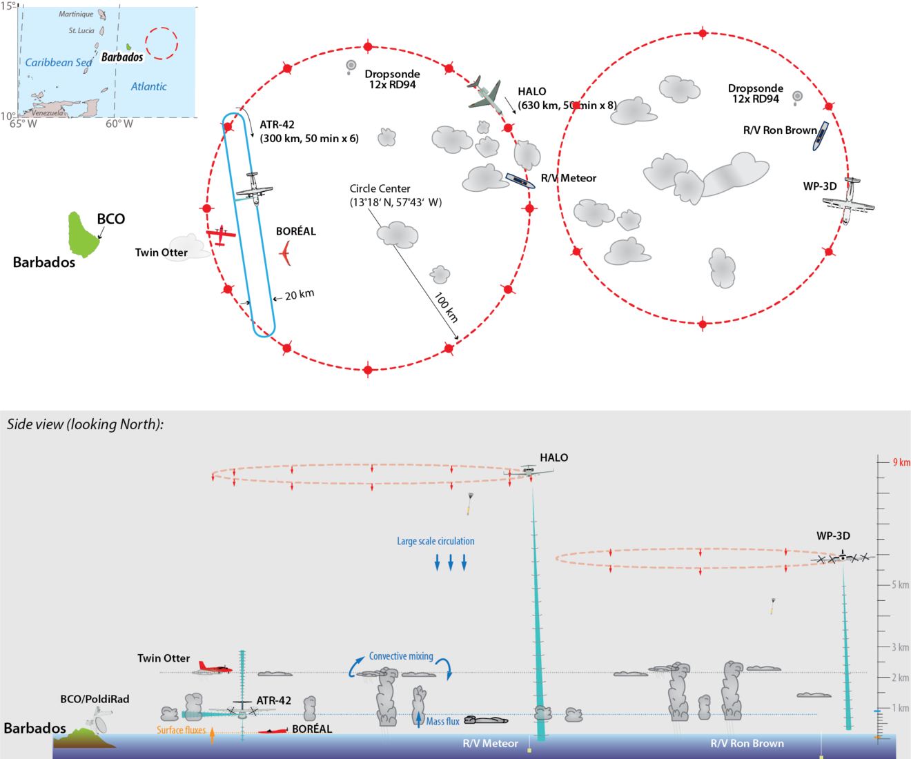
The campaign
The field operations during EUREC4A will be based out of Barbados, and expresses a close and longstanding cooperation with the CIMH as a major scientific partner. For a period of about six weeks, operations will focus on the Atlantic east of Barbados in the northern Tropical Atlantic (57 W, 13 N). More than 40 national and international partner institutions from nine countries (Barbados, France, German, Netherlands, Norway, Poland, Switzerland, UK, USA). The nucleus for the field study involves the deployment of four research aircrafts, four research vessels, repurposed Barbadian aircraft and ships, advanced ground based remote sensing at MPI-M´s Barbados Cloud Observatory (BCO), a new generation of sophisticated satellite remote sensing methods, and coordinated application of a new generation of turbulence-resolving weather models (100 m) over domains spanning thousands of kilometers.
Measuring platforms: aircrafts, research vessels and a cloud observatory
EUREC4A will see the deployment of four research aircraft temporarily based on Barbados, and the coordinated use of a repurposed aircraft from the Regional Security Services (RSS), which is permanently based on Barbados. The French ATR-42 of the Service des Avions Français Instrumentés pour la Recherche en Environnement (SAFIRE) will deploy in-situ and remote sensing sensors in the lower troposphere. BOREAL an autonomous aircraft developed by BOREAL SAS, and previously used by Centre National de Recherches Météorologiques (CNRM) of Météo-France, will make turbulence measurements near the ocean surface. The German research aircraft HALO of the German Aerospace Center (Deutsches Zentrum für Luft- und Raumfahrt; DLR), with a range of up to 8000 km and an upper operating altitude of 15 km. HALO is equipped with an extensive set of remote sensing instrumentation and a dropsonde capability. A Twin Otter from the British Antarctic Survey (BAS), will focus on the measurement of aerosols and the turbulent and microphysical cloud structure. The US research aircraft WP-3D ORION of the National Oceanic and Atmospheric Administration (NOAA) will make measurements complementary to those of the other aircraft, by, among other things, characterizing the large-scale conditions upwind of the main measurement area, and through special night-time operations, characterizing the daily cycle of clouds and their environment. A repurposed aircraft of the RSS will provide reconnaissance of ocean features.
Ship-based observations will expand the range of airborne observations to a larger and, above all, temporally continuous observation area of about 1000 km. A large-scale operation area with four ships is planned. The German research vessels METEO and MARIA S. MERIAN, the MOAA ship RONALD H. BROWN and the French research vessel L'ATALANTE will participate. Support will be provided by ships from the Barbados Defense Force. The research vessels serve as remote sensing and in-situ platforms for both atmosphere and ocean observations. These include radiosondes, lidar and radar techniques as well as balloon kites (“Max Planck CloudKites”) and autonomous flying vehicles.
Measurements from mobile platforms will anchored by measurements from the Barbados Cloud Observatory (BCO). The BCO is a joint facility established through a cooperation among the MPI-M, the CIMH and the Museum of Barbados. Established in 2010 it remains, despite the importance of tropical clouds for climate change, the only advanced cloud observatory in the broader tropics. During EUREC4A the BCO’s ongoing measurements will be complemented intensive characterization of atmospheric particulate matter through additional ground measurements, and through the addition of a large scanning research radar (Polarization Diversity Doppler Radar, POLDIRAD) developed by the German Aerospace Center (DLR). POLDIRAD has a range of 250 km, which will define EUREC4A's main operational area and provide information on the life-cycle of clouds and precipitation.
EUREC4A differs from many other field studies, not only by the amount and degree of coordination in terms of its measurement facilities, but also through its application of novel experimental techniques. These include methods for characterizing the distribution of clouds using the horizontal remote sensing from the French ATR, but also new methods for characterizing the large-scale environment using dropsondes, as demonstrated in earlier, preparatory, field studies.
From Germany, four Max Planck Institutes are involved in the campaign (MPI-M, MPI for Dynamics and Self-Organization, MPI for Chemistry and MPI for Marine Microbiology), five universities (Cologne, Hamburg, Hohenheim, Leipzig and Munich), three Helmholtz institutions (DLR, GEOMAR and HZG), the Leibniz Institute TROPOS and the German Meteorological Service (DWD).
EUREC4A publications
Bony, S., B. Stevens et al.: EUREC4A: A Field Campaign to Elucidate the Couplings Between Clouds, Convection and Circulation. Surv. Geophys. (2017) 38:1529-1568, doi:10.1007/s10712-017-9428-0
Bony, Sandrine, Bjorn Stevens und David Carlson (März 2017). Understanding clouds to anticipate future climate. In: WMO Bulletin 66, S. 8_11. ISSN: 0042-9767.
Bony, S. & Stevens, B. (2019). Measuring area-averaged vertical motions with dropsondes. Journal of the Atmospheric Sciences, 76, 767-783. doi:10.1175/JAS-D-18-0141.1
Konow, Heike, Marek Jacob, Felix Ament, Susanne Crewell, Florian Ewald, Martin Hagen, Lutz Hirsch, Friedhelm Jansen, Mario Mech und Bjorn Stevens (1. Juli 2019). A united data set of airborne cloud remote sensing using the HALO Microwave Package (HAMP). In: Earth System Science Data 11, S. 921_934. ISSN: 1866-3508. doi:10.5194/essd 11-921-2019.
Stevens, B., Ament, F., Bony, S., Crewell, S., Ewald, F., Gross, S., Hansen, A., Hirsch, L., Jacob, M., Kölling, T., Konow, H., Mayer, B., Wendisch, M., Wirth, M., Wolf, K., Bakan, S., Bauer-Pfundstein, M., Brueck, M., Delanoë, J., Ehrlich, A., Farrell, D., Forde, M., Gödde, F., Grob, H., Hagen, M., Jäkel, E., Jansen, F., Klepp, C., Klingebiel, M., Mech, M., Peters, G., Rapp, M., Wing, A. & Zinner, T. (2019). A high-altitude long-range aircraft configured as a cloud observatory – the NARVAL expeditions. Bulletin of the American Meteorological Society, 100, 1061-1077. doi:10.1175/BAMS-D-18-0198.1
Stevens, B., Farrell, D., Hirsch, L., Jansen, F., Nuijens, L., Serikov, I., Brügmann, B., Forde, M., Linné, H., Lonitz, K. & Prospero, J. (2016). The Barbados Cloud Observatory — anchoring investigations of clouds and circulation on the edge of the ITCZ. Bulletin of the American Meteorological Society, 97, 787-801. doi:10.1175/BAMS-D-14-00247.1
Further information
- EUREC4A project website
- Grand Challenge WCRP
- NARVAL measuring campaigns
- 'Focus On' article about NARVAL II
- German Research Fleet Coordination Centre (with weekly updates for METEOR and MARIA S. MERIAN)
- U.S. ATOMIC mission joins with EUREC4A: NOAA Research News
Contact
Prof Dr Bjorn Stevens (Germany)
Max Planck Institute for Meteorology
Phone: +49 (0)40 41173 422 (Assistant Angela Gruber)
Email: bjorn.stevens@mpimet.mpg.de
Dr David Farrell (Barbados)
Caribbean Institute for Meteorology and Hydrology
Phone: 246-425-1362/3/5
Email: dfarrell@cimh.edu.bb
Dr Sandrine Bony (France)
Laboratoire de Météorologie Dynamique (LMD/IPSL)
Phone: + (33) 1 44 27 50 14
Email: sandrine.bony@lmd.jussieu.fr