Artificial Intelligence for the Earth system
“There is truly no shortage of geospatial data but so far we've been lagging behind in analysis and interpretation,” explains Markus Reichstein. Extreme events such as fire spreads or hurricanes are very complex processes influenced by local conditions but also by their temporal and spatial context. This also applies to atmospheric and ocean transport, soil movement and vegetation dynamics, the classic topics of Earth system science.
Artificial intelligence for better climate and Earth System models
However, deep learning approaches are difficult. All data-driven and statistical approaches do not guarantee physical consistency per se, are highly dependent on data quality, and have difficulty extrapolating. Besides, the requirement for data processing and storage capacity is very high. The publication discusses strategies for linking machine learning and physical modelling.
Bringing together physical modelling and machine learning results in so-called hybrid models. These can for example be used for modeling the motion of ocean water to predict sea surface temperature. While the temperatures are modelled physically the ocean water movement is represented by a machine learning approach. “The idea is to combine the best of two worlds –, the consistency of physical models with the versatility of machine learning, – to obtain greatly improved models,” further explains Markus Reichstein.
At MPI-M machine learning is a useful tool for scientists in the departments “The Ocean in the Earth System” and “The Atmosphere in the Earth System”. Dr Peter Landschützer (Ocean Department): “Machine learning has proven to be a powerful tool in reconstructing the annual uptake of carbon dioxide by the ocean. Direct measurements are mostly limited to shipping routes leaving large parts of the ocean - in particular the southern hemisphere - sparsely and heterogeneously sampled or even unobserved. In combination with environmental proxy data, e.g. sea surface temperature and ocean color measurements from satellites, machine learning approaches can establish a connection between the available surface ocean CO2 observations and the proxies which further can be used to fill data gaps. This provides a novel, observational constraint on the marine sink for CO2 and thereby helps to close the global carbon budget.”
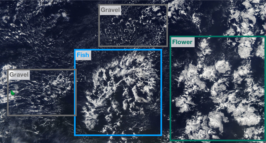
Hauke Schulz, a PhD candidate working with Prof. Stevens has been leading efforts in the Atmosphere Department to use machine learning for cloud structure detection. “Machine Learning is opening new doors in the field of climate science”, he says, and points out how, as part of his research, he “profits from algorithms developed to identify objects in images for face recognition or self-driving cars and transfers them to instead detect cloud structures in satellite images. Just like the automatic detection of faces on social media images, I or rather the computer, gives cloud patterns a name. Combined with auxiliary data this allows us to study the mechanisms leading to different cloud patterns which should help us predict their distribution in a future climate. Without machine learning, it would be hard to imagine how to go about answering the questions we have set for ourselves."
Original publication
Reichstein, M., G. Camps-Valls, B. Stevens, M. Jung, J. Denzler, N. Carvalhais, Prabhat (2019) Deep learning and process understanding for data-driven Earth system science. Nature 566, 195-204. doi: 10.1038/s41586-019-0912-1.
Contact
Prof Dr Markus Reichstein
Max Planck Institute for Biogeochemistry
Phone: +49 (0) 3641 57 6200
Email: mreichstein@bgc-jena.mpg.de
Prof Dr Bjorn Stevens
Max Planck Institute for Meteorology
Phone: +49 (0) 40 41173 422 (Assistant Angela Gruber)
Email: bjorn.stevens@mpimet.mpg.de

