Revisiting the Blue Marble: ICON simulating the coupled climate system at 1 km
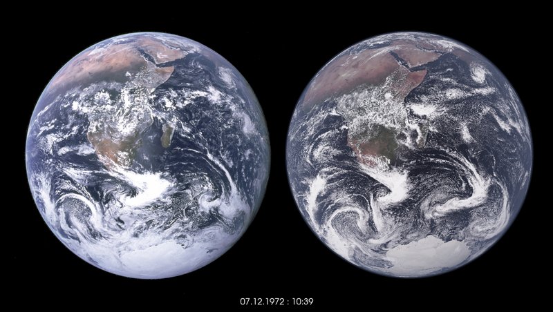
One undeniably influential moment in this early history of growing environmental awareness, which led to many of the subsequent events, was the famous photograph of a fully illuminated Earth, taken at 10:39 UTC on 7 December 1972, by astronauts on their way to the moon aboard Apollo 17. Apollo 17 was the last crewed lunar mission, and perhaps its greatest legacy was this photograph, named the Blue Marble. The photograph is often credited with supporting a growing global consciousness, as relates to issues of peace, solidarity, sustainability and environmental protection. It is hard to overstate the importance of the Blue Marble, which Wikipedia describes as “one of the most reproduced images in history.”
In reflecting on the origins of our institute, we were reminded of these events, poignantly of the approaching fiftieth anniversary of the Blue Marble. What struck us, was how much an image could move people to see the world, and their place in the world in a new way, and what this implied for our newfound capacity to construct such images out of the crucible of physical laws. In early October of 2022 our institute had finally managed the first demonstration of an ability to simulate the fully coupled climate systems at the scale of a km. Processes that can be resolved by kilometer scale simulations are believed to be fundamental for understanding how global warming reshapes Earth’s climate. Demonstrating this capability to simulate the Earth at the scale required to make more reliable projection, if only for a few simulated days, was a major achievement.
To celebrate the achievement, and the power that comes with visualizing who we are and where we are going, the MPI-M joined together with NVIDIA and the German Climate Computing Center, to simulate the iconic Blue Marble. We initialized the simulations from a spun-up ocean, two days before the famous photograph. Essentially, fifty years too late, we were creating a two-day forecast of the image the astronauts would then capture. But unlike the superficial beauty of the sun’s light reflected by our Earth into the astronaut´s camera lens, our Blue Marble is connected together by the laws of physics, which brings it into life and into motion. This enables us to see the pattern of surface winds behind the cloud fields, filaments of warm water as they are stretched southward along Africa’s south-east coast or of cold water pulled from depth off its southwest coast. Eddies as they might have existed at the time are being launched into the Atlantic from the retroflection of the Agulhas Current. The simulations allow us to dive deep to study eddies well below the water’s surface, or to rise up with convective currents following the march of the sun across the land surface.
We’ve come a long way since 1972, but now the tools we need to understand the implications of global warming are at the tips of our fingers, and motivate the increasing call for coordinated efforts to take advantage of the technologies these simulations highlight, to make the best possible simulations of the climate system, to better anticipate what the future might hold, and by working together to do so, to strength the global consciousness that will be needed to effectively manage our planet.
Notes on the simulation and visualization:
The simulations cap two decades of effort in the development of the coupled atmosphere, ocean, land climate model known as ICON. We used the latest ICON-2.6.6-rc and ran it in the R02B11 resolution with 90 vertical level in the atmosphere (335544320 grid points per level) and 128 vertical level in the ocean (237102291 surface grid points). We use JSBACH-lite as the land model. We used observed aerosols and greenhouse gas concentrations of December 1972. The atmosphere uses a time-step of 8s and the ocean 45s. We ran the simulation on 900 nodes of Levante (128 cores per node, AMD EPYC Milan CPUs) at DKRZ and use a split of 24:8 (atm:oce) mpi tasks per node, with 4 openMP threads. In total we get a throughput of about 3 simulated days per day with those 900 nodes (about 1/3 of Levante).
The ocean, we initialized from ORAs5 on 1969/01/01, ran the ocean alone at 5 km resolution for nearly four years (until 1972/11/01) with ERA5 forcing at the upper boundary. Then, we interpolated the ocean state to the 1 km grid and ran the ocean for another 5 weeks, until 1972/12/5 00 UTC, again with ERA5 forcing at the ocean surface. Now we coupled the model, and initialized the atmosphere from ERA5 reanalysis on the 1972/12/05 00 UTC and ran the coupled system until 1972/12/08 12 UTC. It is remarkable, that we got the conditions of the Blue Marble so well, as at the time, there were very limited observations going into the reanalysis, especially for the southern hemisphere we look at.
The data is visualized in NVIDIA Omniverse and rendered using the internal RTX pathtracer. As pre-processing step, textures in the size of up to 32k x 16k have been created from the simulation output using Python and ParaView. To annotate the scene we use an Earth map from the NASA visible Earth database, and accentuate the surface, using a normal map that also integrates the Ocean’s surface velocity, which can be observed as Eddies reflecting in the sun light. The advanced rendering and the use of textures allows us to almost interactively visualize the data and also scrub through the time steps in real-time.
The development of ICON, started as and remains a collaboration between the Max Planck Institute for Meteorology and the German Weather Service. Recently the German Climate Computing Center, the ETH Center for Climate System Science, and the Karlsruhe Institute for Technology, joined the ICON development. This highlights how major milestones take the coordinated efforts of many, in our case, hundreds of scientists and technologists over years. The team that led this specific effort, to recreate a virtual Blue Marble, consisted of Hendryk Bockelmann (DKRZ), Niklas Röber (NVIDIA), Helmuth Haak, Daniel Klocke, René Redler and Bjorn Stevens (MPI-M). Support from European and German national projects NextGEMS, WarmWorld and ESIWACE is greatfully acknowledged.
Further information:
- The Blue Marble article on Wikipedia
- Nobel Prize in Physics 2021 for Klaus Hasselmann
- Obituary Reimar Lüst
- Nine of the world´s leading climate scientists are calling for major international investment to develop a new generation of climate models that can answer fundamental questions about the predictability of future precipitation and related extreme events
- The nextGEMS project is building prototypes for a new generation of Earth system models to advance science, guide policy, and inform applications to support the sustainable management of our planet.
- About NVIDIA Omniverse for scientific visualization
Contact:
Dr. Hendryk Bockelmann
German Climate Computing Center (Deutsches Klimarechenzentrum, DKRZ)
Email: bockelmann@dkrz.de
Dr. Niklas Röber
NVIDIA
Email: nroeber@nvidia.com
Prof. Bjorn Stevens
Max Planck Institute for Meteorology
Email: bjorn.stevens@mpimet.mpg.de